Life at the Fenceline: Understanding Cumulative Health Hazards in Environmental Justice Communities
Haga clic aquí para materiales en Español
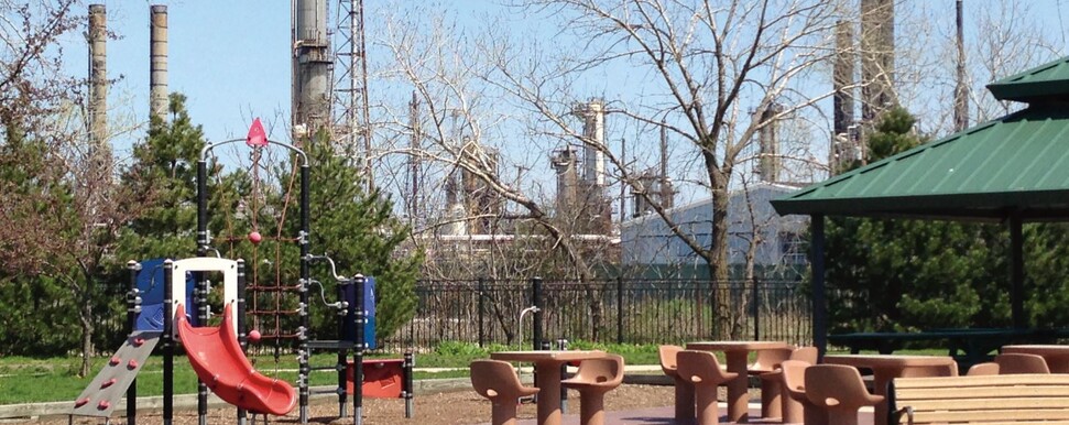
Across the United States, almost 12,500 high-risk chemical facilities put 39% of the US population (124 million people) who live within three miles of these facilities at constant risk of chemical disaster. The full vulnerability zones for these industrial and commercial sites can extend up to twenty-five miles in radius.
Many communities of color and low-income communities face disproportionate risk from these facilities, which are loosely regulated under the U.S. Environmental Protection Agency’s Risk Management Plan (RMP) program. The health and safety of these communities is also at risk from many other threats, including potential chemical releases or explosions, but also daily exposure to toxic air pollution (from these facilities and other sources) and lack of access to healthy foods. Many of these communities also rely on dollar stores for household necessities and even food, making these retailers potential sources of either additional toxic exposures or safer products and healthier foods.
Life at the Fenceline: Understanding Cumulative Health Hazards in Environmental Justice Communities sought to identify and understand several interconnected health and environmental impacts in Environmental Justice communities and identify solutions. We looked at key data nationally and additional data for nine EJ communities: Los Angeles, as well as Kern, Fresno, and Madera counties, CA; Houston and Dallas, TX; Louisville, KY; Albuquerque, NM; and Charleston, WV. We studied:
- Who lives in close proximity to the most hazardous chemical facilities?
- What cancer and respiratory illness risks do people living within 3 miles of these facilities face from toxic air pollution?
- Do these communities have access to healthy foods?
- Where are key institutions (schools, hospitals and nursing homes, and dollar stores) located in these “fenceline zones”?
Analysis of the 9 areas studied for this report clearly shows that:
- In most of the areas researched, large majorities of the population live in fenceline zones around highly hazardous facilities, and most schools and medical institutions are located in these zones, at much greater rates than nationally. In 7 of the 9 areas researched for this report, two-thirds of the population or more live in fenceline zones (much greater than the national rate of 39%). In most of the areas studied, at least two-thirds of all schools and 70% of medical facilities are located in fenceline zones (compared to 45% of US schools and 39% of US hospitals and nursing homes).
- Fenceline zones around hazardous facilities are disproportionately Black, Latino, and impoverished. The percentage of Blacks or Latinos living within 3 miles of a Risk Management Plan (RMP) facility was higher than for the entire area in every study area, and often much higher than for the US as a whole. In 7 of the 9 areas researched, the percentage of people living in poverty within 3 miles of an RMP facility is higher than for those living in poverty in the entire area, and often much higher than for the US as a whole.
- People living in hazardous facility fenceline zones face multiple health hazards and risks. In addition to the constant threat of catastrophic chemical releases or explosions, in every area researched for this report fenceline zones face higher risk of cancer from toxic air pollution than the entire area (and often much higher than for the US as a whole). In 8 of the 9 areas, the potential for respiratory illness is higher in fenceline zones than for the entire area, and in every area is above the national rate. The percentage of fenceline zone residents who also live in a low- income/low food access area is higher than for the entire city or county in all 9 areas (and two to three times the national rate in most areas).
- The most vulnerable neighborhoods—areas that are both low-income and have low access to healthy foods—are even more heavily and disproportionately impacted. In every area studied, low-income/low food access areas within fenceline zones have higher poverty rates, greater percentages of residents who are people of color, and higher cancer risk and respiratory hazard from toxic air pollution than for the whole fenceline zones or the entire city or county, often much higher.
Learn about Life at the Fenceline using these materials:
- Life at the Fenceline: Understanding Cumulative Health Hazards in Environmental Justice Communities (full report)
- Interactive map (including Risk Management Plan facilities across the US, and detailed maps of facilities, schools, medical institutions and dollar stores in nine local areas
- Detailed fact sheets (including additional maps showing schools, medical institutions, and dollar stores within fenceline zones) on:
- Additional maps of Houston and Los Angeles:
- Houston Hazardous Facility Fenceline Zones, Schools, and Race
- Houston Hazardous Facility Fenceline Zones, Medical Instutitions, and Race
- Houston Hazardous Facility Fenceline Zones, Dollar Stores, and Race
- Los Angeles Hazardous Facility Fenceline Zones, Schools, and Race
- Los Angeles Hazardous Facility Fenceline Zones, Medical Instutitions, and Race
- Los Angeles Hazardous Facility Fenceline Zones, Dollar Stores, and Race
- EJHA’s previous report Who’s in Danger? Race, Poverty, and Chemical Disasters
- La Vida Al Borde: Entendiendo los Riesgos Acumulados a la Salud en Comunidades de Justicia Ambiental (informe completo)
- Una mapa interactiva de las instalaciones de RMP en EE. UU., así como mapas de las áreas locales estudiadas
- Hojas Informativas Locales:
- Mapas Adicionales para Houston y Los Angeles:
- Houston Zonas Aledañas Alrededor Instalaciones Peligrosas, Escuelas, y Raza
- Houston Zonas Aledañas Alrededor Instalaciones Peligrosas, Instalaciones Médicas, y Raza
- Houston Zonas Aledañas Alrededor Instalaciones Peligrosas, Tiendas de Dólar, y Raza
- Los Angeles Zonas Aledañas Alrededor Instalaciones Peligrosas, Escuelas, y Raza
- Los Angeles Zonas Aledañas Alrededor Instalaciones Peligrosas, Instalaciones Médicas, y Raza
- Los Angeles Zonas Aledañas Alrededor Instalaciones Peligrosas, Tiendas de Dólar, y Raza